Research Article | | Peer-Reviewed

Sustainable Transportation System for Rajshahi City, Bangladesh

Received: 13 May 2024     Accepted: 11 June 2024     Published: 29 July 2024
Views:       Downloads:
Abstract

The ultimate objective of this project is to make a meaningful contribution to the ongoing research on sustainable development and to aid in developing and implementing an efficient transportation system that effectively tackles the challenges of mobility and environmental security challenges in the bustling city of Rajshahi. As part of this effort, our paper will present a comprehensive overview of recent advancements and key findings in the field of sustainable transportation. In the process, the paper will offer an overview of some of the most recent and useful developments in the subject of study. One of the key challenges in achieving sustainable transportation in Rajshahi is the inadequate road infrastructure, such as ill-defined road markings, lack or insufficiency of traffic signs, and rampant illegal parking, particularly in peripheral areas. These factors not only hinder smooth traffic flow but also threaten the safety of drivers, increasing their vulnerability to accidents. Additionally, they contribute to traffic congestion and other inconveniences for commuters. Hence, it is imperative to adopt a holistic approach to tackling these issues to promote sustainable transportation within Rajshahi City. This requires collaboration between various stakeholders and implementing comprehensive solutions that address multiple facets of sustainable transportation. Only through such concerted efforts can we effectively overcome the challenges hindering efficient mobility in Rajshahi.

Published in International Journal of Transportation Engineering and Technology (Volume 10, Issue 2)
DOI 10.11648/j.ijtet.20241002.11
Page(s) 25-38
Creative Commons

This is an Open Access article, distributed under the terms of the Creative Commons Attribution 4.0 International License (http://creativecommons.org/licenses/by/4.0/), which permits unrestricted use, distribution and reproduction in any medium or format, provided the original work is properly cited.

Copyright

Copyright © The Author(s), 2024. Published by Science Publishing Group

Keywords

Sustainable Development, Transportation System, Environmental Security, Road Markings, Traffic Signs, Illegal Parking

1. Introduction
Sustainable improvement is an adaptable method that optimizes using what is to be had, assembling present needs at the same time as making adjustments for changes within the future. Rajshahi City receives several visitors, mainly during peak hours, which causes annoyance and long journey instances. Adoption of sustainable mobility is further hampered by insufficient infrastructure for bicycling, on foot, and public transportation. Issues with road markings include diminished or lacking markers, erroneous placement, insufficient methods, inadequate preservation, worse site visitor congestion, and the possibility of collisions. Unofficial parking lots and insufficient parking in commercial enterprise districts are elements that result in troubles with land use and urbanization. Rajshahi City has to create sustainable transportation systems to cope with these problems to protect social justice, take care of environmental worries, reduce traffic, promote financial growth, and create a first-class life for its citizens
Road markings are important to transportation engineering due to the fact they enhance safety measures, manage web page site visitors, and optimize space use. To make secure tours for cars and pedestrians simpler, they provide substantive notifications. According to the current examination, avenue markers are critical for decreasing traveler accidents and growing visibility at night time. Different styles of pavement markings have diverse capabilities, which include communicating felony records, figuring out intersections, and figuring out roads. Moreover, pavement-set-up signs and symptoms and emblems facilitate secure journeys on hard roadways. Street markings are a suitable part of the transportation infrastructure because they decorate device performance, alter traffic patterns, and grow public protection.
Traffic engineers are accountable for determining appropriate places for roadside parking that permit lawful prevention and efficient car movement. These reputable halting spots are decided through professional evaluation achieved by capable specialists, considering variables along with visitors' styles, safety precautions, accessibility of entry factors, and requirements for neighboring belongings usage. Through careful optimization of roadside parking opportunities, they thoroughly find appropriate placements inside to be had space allocations, considering a call for degrees and utilization tendencies. This methodical technique results in a much broader range of mobility alternatives .
The intersection of extra roads consequences in an increasing community, which will increase the relationship and warfare between special varieties of transportation and make avenue intersections an essential part of transportation engineering. In these environments, it is important to apply skilled design methodologies and combine modern-day technology with efficient control mechanisms to maximize traveler flow. By doing this, availability across multimodal transportation networks may be advanced even as additionally decreasing congestion with the aid of marketing protection measures for less complicated travel .
Urban transportation also has to deal with road risks such as poor safety, environmental pollution, and traffic congestion, among others. Badly placed infrastructure and insufficiencies, especially for the bikes and pedestrians who have people power to make the economy, lower their accessibility to the services. The impacts are broad and extend to public health, environmental sustainability, and inhibition of economic growth and developmental advancement. For efficient and sustainable transportation, problems associated with traffic congestion, pollution, and modernization of infrastructure need to be solved
Commutators are troubled by traffic congestion. It's an annoying, bothersome worry. Simplifying transportation and eliminating traffic jams are our main goals. We also plan signals that lower the likelihood of accidents. Safety is important. Accidents won't happen. Environmental effects frighten people. We want to minimize damage and guarantee everyone's safety on the roadways.
2. Literature Review
The fundamental need in a transportation system is parking. But more often than not, its effect on how efficiently traffic moves passes us by. This is because, whereas parking entails the state in which the vehicles are stationary, our understanding of transportation is restricted to the idea of motion. The management of the transportation system is becoming increasingly important since it impacts a city's overall accessibility .
Cars in the New Market neighborhood typically park for 45 minutes, but some people leave their cars parked for up to five hours, according to a recent study. There are now fewer parking spots available in the vicinity as a result of the prolonged parking period. To analyze the parking situation in New Market, a well-known shopping area, the study will look at how supply and demand for parking are balanced as well as possible solutions to the current parking issues. Using patrol methods, researchers surveyed the inventory and usage of parking spaces over the course of two typical workdays. The study's conclusions suggest putting particular policies into place to deal with the problems found in an efficient manner .
The largest and busiest city in Bangladesh, Rajshahi is known for its vibrant commercial, educational, and government services. Widely recognized as a national learning center. The city’s traffic is expanding day by day, which means slowly increasing numbers of vehicles are entering the road, and traffic congestion is getting worse Before 2008, rickshaws were the main mode of rapid travel in Rajshahi Municipal Corporation boundaries .
The purpose of this project is to use the VISSIM tool to develop and assess a traffic-light-controlled intersection model to reduce congestion. The current state of the model, as well as two altered states intended to increase throughput by reducing queue lengths, were simulated. The suggested modifications resulted in a 75% decrease in average queue length, which significantly shortened wait times for drivers in busy regions. The second change reduced waits in other-directional queues and enhanced turn-right convenience. This study shows how transformational virtual software systems, such as VISSIM, can reduce traffic congestion brought on by heavy vehicle volume loads and enhance intersection performance .
The goal of the study was to address crowded routes to optimize traffic signal controllers in Sri Lanka. It was able to successfully cut emissions and fuel consumption by 14.89% and 14.11%, respectively, by using the VISSIM microsimulation tool. The suggested methodology offers a workable substitute for current methods since it offers a productive way to enhance traffic signal controller performance without causing any hiccups or delays .
Another large, divided, and growing Bangladeshi city, Rajshahi Metropolitan City, shows a daily increase in population density. Even if the city's transportation systems are currently in a moderate state of condition, the maintenance and management procedures are insufficient .
Rajshahi City Corporation is an urban area in northwest Bangladesh that is characterized by diversity, prosperity, and a strong emphasis on agriculture, culture, and education. This article presents an evaluation of the current state of affairs at the Rajshahi City Corporation Area signalized crossroads in Rajshahi, Bangladesh. Since traffic modeling and simulation are often used methods in road system design, micro-simulation-based modeling was also utilized to determine the ideal signal time. An essential auxiliary tool in decision-making and choosing the best course of action is traffic simulation software .
3. Methodology
3.1. For Safety Signs & Road Markings
To support the research, extensive visual and physical surveys were carried out in carefully chosen areas throughout Rajshahi City's urban landscape. For the safety of such fast-moving vehicles on this route, appropriate road safety signs, symbols, and markings are essential. Five areas (Vodra, Station Road, Railgate, Kadirganj & Laxmipur) were selected randomly for the study due to time limitations and all the areas of Rajshahi city were not possible within the time. Walk-down observation was carried out to verify the situation of the signs, symbols, and road markings regarding road safety. The traffic signs and symbols are not sufficient in terms of public safety, the ones, that are present, are not being obeyed properly by the mass people. So, people are always at risk .
3.2. For Intersections Analysis
There are sixteen signalized junctions in the city, all of which are under the management of the Rajshahi City Corporation. Two of these intersections—Talaimari Mor and Kadirganj Mor were primarily chosen because of their importance to urban traffic flow and will be taken into account in detail. However, before a large-scale data collection was started on; a thorough field assessment was carried out to get an insight into the dynamics of the study area.
The study focused on vehicular interactions without pedestrian crossings at selected locations, avoiding on-street parking activities. Careful inspections of crossings improved precision in measurements and observations. Two-day research was conducted at each intersection, capturing peak traffic volumes and driving habits during peak hours between 5: 00 PM and 6: 00 PM, ensuring accurate representation of traffic patterns .
In order to ensure that results are accurate as well as reliable, data gathering on vehicle counts had been done with extreme caution using books. Furthermore, comprehensive evaluation of both traffic volume classification and turning movements analysis for all intersections was made to understand better. This effort is intended to address some types of vehicles that can be found in busy urban areas within Rajshahi town where there might be complex structures in mode-specific distribution
3.3. For Parking Analysis
The study makes use of 3 survey procedures to collect particular statistics on parking in Rajshahi City, specializing in 4 intersections (Talaimari Mor, Mintu Chattar/ Laxmipur Mor, Moni Chattar, Bindur Mor/ Railgate, Vodra) and reviewing literature two times to discover capacity regions for similar investigation.
The research aimed at gathering data on parking availability, usage, and locations in specific regions using various approaches such as identifying available spaces, conducting surveys, and undertaking field operations. The study objectives directed the research; this ensured that data collection was in line with the objectives of the project thus facilitating decision-making.
To ensure a precise representation of typical traffic patterns in Rajshahi City, a methodological approach for the survey was carefully considered, and data collection was confined to weekdays. The following day, over three hours and five minutes, a parking utilization study was carried out, which involved counting the number of parked cars every thirty minutes. To gather information, in-depth use investigations were carried out on five specific intersections. Each piece of data was carefully entered and examined in the Microsoft Excel application, which produced the required inferences and findings.
4. Data Collection & Analysis
4.1. Analysis of Safety Signs & Road Markings
Several particular locations in Rajshahi City’s urban setting were chosen for both visual and physical investigations. The condition of road markings, signs, and symbols related to road safety was assessed using walk-down observations. Field investigations and interviews with traffic police officers who were presently on duty were used in the data collection process.
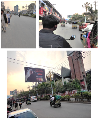
Figure 1. Road markings are absent on Vodra, Station Road, and Laxmipur.
When lane markers are absent from a road, it puts drivers in danger. Drivers may find it difficult to maintain their lane position in the absence of obvious separation, which could result in occurrences like head-on collisions or side-swipe incidents. Furthermore, drivers find it more difficult to calculate safe passing distances when there are no lane markers, which raises the possibility of unsafe overtaking tactics. Overall road safety is impacted by drivers’ doubt and confusion caused by this lane demarcation’s lack of clarity. To enhance traffic flow and lower the likelihood of accidents on the road, lane marker absence must be addressed. Encouraging safer driving practices and improving driver awareness can be achieved through the use of obvious lane markings. Lane markings are effectively implemented in those places.
There is no zebra crossing sign and the road cross signs are unclear. Both vehicles and pedestrians are endangered by dangerous road crossings. This is because there aren’t sufficient poles to show where the pedestrian paths meet, making people confused and increasing the chances of accidents, particularly in areas with a lot of traffic from both cars and people walking on foot. Therefore, it will be crucial to resolve any potential crossing issues that arise out of ambiguity to ensure the highest levels of safety on our highways thereby minimizing the frequency with which such occurrences take place.
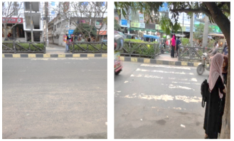
Figure 2. Unclear Pedestrian Crossing Signage on a Road.
4.2. Data Collection & Analysis of Road Intersections
4.2.1. Data Collection for Kadirganj Intersection
Traffic surveys at the intersection were carried out on normal working days of the week from 5 to 6 pm and thus classified turning movements at the intersections were arrived at.
According to IRC, Different Vehicles in PCU
Table 1. Traffic in PCU from Uposhohor.

Uposhohor

Items

Total Vehicle No.

PCU Factor

In PCU

Auto Rickshaw

138

1

138

Rickshaw

277

1.5

416

Van

7

1.5

11

Cycle

66

0.5

33

Bike

100

0.5

50

Bus

1

3

3

Truck

0

3

0

Car

30

1

30

CNG

4

1

4

Total in PCU

685

Table 2. Traffic in PCU from Mohila College Road.

Mohila College Road

Items

Total Vehicle No.

PCU Factor

In PCU

Auto Rickshaw

81

1

81

Rickshaw

128

1.5

192

Van

10

1.5

15

Cycle

220

0.5

110

Bike

98

0.5

49

Bus

0

3

0

Truck

1

3

2

Car

13

1

13

CNG

2

1

2

Total in PCU

464

Table 3. Traffic in PCU from Railgate.

Railgate

Items

Total Vehicle No.

PCU Factor

In PCU

Auto Rickshaw

541

1

541

Rickshaw

215

1.5

323

Van

23

1.5

35

Cycle

234

0.5

117

Bike

260

0.5

130

Bus

20

3

60

Truck

15

3

45

Car

102

1

102

CNG

12

1

12

Total in PCU

1365

Table 4. Traffic in PCU from Bornali.

Bornali

Items

Total Vehicle No.

PCU Factor

In PCU

Auto Rickshaw

409

1

409

Rickshaw

199

1.5

298

Van

33

1.5

49

Cycle

214

0.5

107

Bike

294

0.5

147

Bus

18

3

53

Truck

14

3

43

Car

67

1

67

CNG

24

1

24

Total in PCU

1197

The Peak Hourly Volume (PHV) for different roads in the area is as follows:
Uposhohor experiences a PHV of 685 Passenger Car Units (PCU), while Mohila College Road sees a PHV of 464 PCU. Railgate Road records the highest PHV at 1365 PCU, and Bornali Road follows closely behind with a PHV of 1197 PCU.
The current roadway system of Kadirganj has been illustrated in Figure 3.
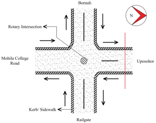
Figure 3. Current Model of Kadirganj Intersection.
When vehicles want to move from Railgate to Bornali vehicles coming from Mohila College Road conflict with them and cause traffic jams. Again, vehicles that want to move Bornali to Railgate conflict with the vehicles coming from Uposhohor. There is a small rotary in the middle of the intersection. This rotary is not quite enough to minimize the traffic jam, because it is only provided for the standing of traffic police. There is a conventional traffic signaling system that is now not valid.
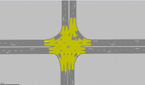
Figure 4. Conflict Areas from VISSIM.
New Signalized Model Establishment in Figure 5.
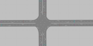
Figure 5. New Traffic Signal Placement of Kadirganj Intersection.
A fixed time signal phasing with a 120-second cycle length, 3-second yellow clearance, and all red and green time are given in the results.
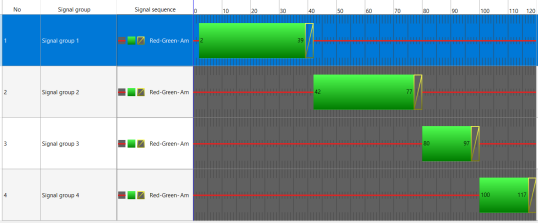
Figure 6. Four-Phase Bit Timing Diagram.
4.2.2. Data Collection for Talaimari Intersection
According to IRC, Different Vehicles in PCU
Table 5. Traffic in PCU from Vodra.

Vodra

Items

Total Vehicle No.

PCU Factor

In PCU

Auto Rickshaw

225

1

225

Rickshaw

335

1.5

503

Van

75

1.5

113

Cycle

114

0.5

57

Bike

147

0.5

74

Bus

49

3

147

Truck

17

3

51

Car

44

1

44

CNG

5

1

5

Total in PCU

1218

Table 6. Traffic in PCU from Zero Point.

Zero Point

Items

Total Vehicle No.

PCU Factor

In PCU

Auto Rickshaw

285

1

285

Rickshaw

311

1.5

467

Van

87

1.5

131

Cycle

81

0.5

41

Bike

180

0.5

90

Bus

10

3

30

Truck

5

3

15

Car

63

1

63

CNG

8

1

8

Total in PCU

1129

Table 7. Traffic in PCU from Kazla.

Kazla

Items

Total Vehicle No.

PCU Factor

In PCU

Auto Rickshaw

713

1

713

Rickshaw

682

1.5

1023

Van

85

1.5

128

Cycle

228

0.5

114

Bike

328

0.5

164

Bus

80

3

240

Truck

19

3

57

Car

150

1

150

CNG

14

1

14

Total in PCU

2603

Table 8. Traffic in PCU from Phultala.

Phultala

Items

Total Vehicle No.

PCU Factor

In PCU

Auto Rickshaw

63

1

63

Rickshaw

214

1.5

321

Van

24

1.5

36

Cycle

137

0.5

69

Bike

101

0.5

51

Bus

0

3

0

Truck

0

3

0

Car

12

1

12

CNG

3

1

3

Total in PCU

554

The Peak Hourly Volume (PHV) for different roads in the area is as follows:
Phultala experiences a PHV of 554 Passenger Car Units (PCU), while Zero Point sees a PHV of 464 PCU. Kazla Road records the highest peak hour volume (PHV) at 2603 PCU, while Vodra Road follows with a PHV of 1218 PCU.
The current roadway system of Talaimari has been illustrated in Figure 7.
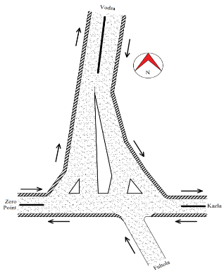
Figure 7. Current Model of Talaimari Intersection.
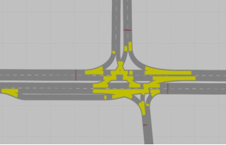
Figure 8. Conflict Areas from VISSIM.
Figure 8 shows the intersection model using PTV Vissim software. The yellow marking of the intersections indicated conflict zones. Traffic jams occur at marked intersections due to the heavy flow of vehicles. As a result, traffic takes more time, and accidents often occur.
New Signalized Model Establishment in Figure 9.
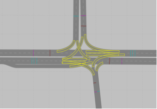
Figure 9. New Traffic Signal Placement of Talaimari Intersection.
A fixed time signal phasing with a 120-second cycle length, 3-second yellow clearance, and all red and green time is given in the results.
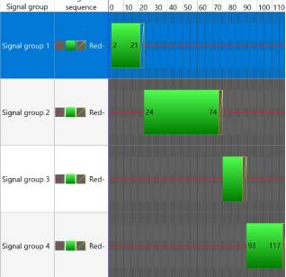
Figure 10. Four-Phase Bit Timing Diagram.
4.3. Analysis of Road Parking
Talaimari Intersection:
The Dhaka-Rajshahi highway intersects in Talaimari. This intersection has three legs and is not signalized.
In Figure 11 designated parking areas are represented by blue markers, while illegal parking on the road is indicated by red markers. There are three types of modes of parked vehicles such as easy bike (55%), auto-rickshaw (26%), and bicycle (19%).
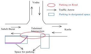
Figure 11. Location of Parking in Talaimari.
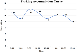
Figure 12. Accumulation Curve of Illegal Parking in Talaimari.
The total parking volume over 3.5 hours is 70 vehicles in Figure 12. So, the average volume is 20 vehicles/hour. That means on average every hour 20 new vehicles come into this intersection. The parking alignment technique is mixed (90 degrees and parallel). The effective carriage width of the road is reduced to 32 feet due to illegal parking. However, without any parking, the effective carriage width expands to 40 feet.
Laxmipur Intersection
Laxmipur is a signalized intersection, but the signal does not work. It is a four-leg intersection.
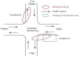
Figure 13. Location of Parking in Laxmipur.
In Figure 13, location A (East side of the intersection), parking of slow-moving vehicles is on the road and beside the road. In location B (North side of the intersection), parking of slow-moving vehicles is only on the road.
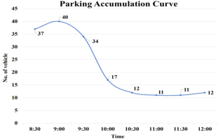
Figure 14. Accumulation Curve of Parking at Location A in Laxmipur.
The total parking volume over 3.5 hours is 174 vehicles Figure 14. So, the average volume is 49.71 vehicles/hour. That means on average in every hour 38.28 new vehicles come into this parking bay. The parking accumulation curve is falling significantly, because, day laborers park their bicycles beside the road at the stated location of parking. And they are waiting until get any work. Within 10.00 AM they get their job and after that, there is no bicycle. The effective carriage width of the road is reduced to 14 feet due to illegal parking. However, without any parking, the effective carriage width expands to 26 feet.
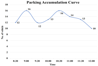
Figure 15. Accumulation Curve of Parking at Location B in Laxmipur.
The total parking volume over 3.5 hours is 106 vehicles Figure 15. So, the average volume is 30.28 vehicles/hour. That means on average 30.28 new vehicles come into this intersection every hour. The effective carriage width of the road is reduced to 26 feet due to illegal parking. However, without any parking, the effective carriage width expands to 32 feet.
Moni-Chattar Intersection:
Moni chattar is a non-signalized and three-leg intersection.
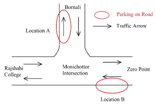
Figure 16. Location of Parking in Moni Chattar.
In location A (East side of the intersection), parking of slow-moving vehicles is on the road. In the case of location B (North side of the intersection), parking of slow-moving vehicles is also on the road shown in Figure 16. Parking on the road is illegal parking.
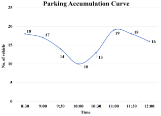
Figure 17. Accumulation Curve of Parking at Location A in Moni Chattar.
The total parking volume over 3.5 hours is 117 vehicles Figure 17. So, the average volume is 33.42 vehicles/hour. That means on average in every hour 33.42 new vehicles come into this parking bay. The effective carriage width of the road is reduced to 8 feet due to illegal parking. However, without any parking, the effective carriage width expands to 22 feet.
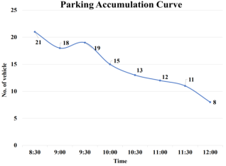
Figure 18. Accumulation Curve of Parking at Location B in Moni Chattar.
The total parking volume over 3.5 hours is 125 vehicles Figure 18. So, the average volume is 35.71 vehicles/hour. That means on average in every hour 35.71 new vehicles come into this intersection. The effective carriage width of the road is reduced to 9.2 feet due to illegal parking. However, without parking, the effective carriage width expands to 26.5 feet.
Railgate Intersection:
Railgate is the busiest intersection among these four intersections. It is a four-leg intersection.
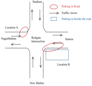
Figure 19. Location of Parking in Railgate.
In Figure 19 shown, location A (West side of the intersection), parking of slow-moving vehicles is only on the road and location B (East side of the intersection), parking of slow-moving vehicles is on the road and beside the road.
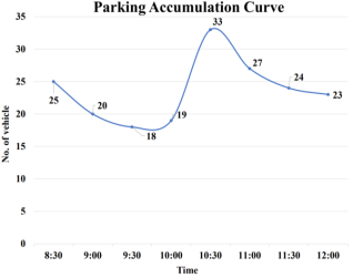
Figure 20. Accumulation Curve of Parking at Location A in Railgate.
The total parking volume over 3.5 hours is 189 vehicles Figure 20. So, the average volume is 54 vehicles/hour. That means on average in every hour 54 new vehicles come into this intersection. The effective carriage width of the road is reduced to 36.2 feet due to illegal parking. However, without any parking, the effective carriage width expands to 52 feet.
Figure 21. Accumulation Curve of Parking at Location B in Railgate.
The total parking volume over 3.5 hours is 208 vehicles in Figure 21. So, the average volume is 59.43 vehicles/hour. That means on average in every hour 59.43 new vehicles come into this intersection. The effective carriage width of the road is reduced to 38.5 feet due to illegal parking. However, without any parking, the effective carriage width expands to 46.7 feet.
Vodra Intersection:
Vodra Intersection in Rajshahi is a vital junction notorious for its traffic congestion and safety issues.
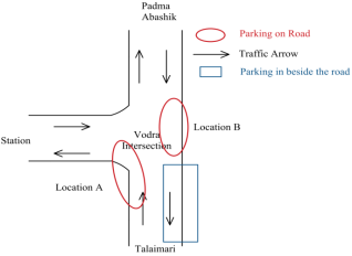
Figure 22. Location of Parking in Vodra.
In Figure 22, location A (West side of the intersection), parking of slow-moving vehicles is only on the road, and location B (East side of the intersection), parking of slow-moving vehicles is on the road and beside the road.
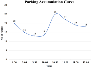
Figure 23. Accumulation Curve of Parking at Location A in Vodra.
The total parking volume over 3.5 hours is 146 vehicles Figure 23. So, the average volume is 41.71 vehicles/hour. That means on average in every hour 41.71 new vehicles come into this.
The total parking volume over 3.5 hours is 256 vehicles Figure 24. So, the average volume is 73.14 vehicles/hour. That means on average in every hour 73.14 new vehicles come into this intersection.
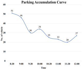
Figure 24. Accumulation Curve of Parking at Location B in Vodra.
5. Result & Discussion
Our examination of the chosen regions revealed differences in the availability of vital road infrastructure. Pedestrian crossings, warning signs, and traffic markings were all present in certain areas (such as CNB Road, and Saheb Bazar) but not in others (like Vodra Road, Station Road, Laxmipur Road, etc.). These results highlight the necessity of focused initiatives to raise road safety and maintain uniform infrastructure throughout Rajshahi City.
To assess the efficiency and effectiveness of traffic management systems, several parameters were taken into account when analyzing signalized road intersections. This involved looking at safety precautions, traffic signal compliance, congestion levels, and patterns of traffic flow. To evaluate the effectiveness of signal timing, coordination, and total intersection capacity, data gathered from signalized intersections including Talaimari and Kadirganj were evaluated. The results offered fresh insights into the operational characteristics of signalized intersections and underscored opportunities for optimizing urban traffic management.
In our analysis of the parking situation in Rajshahi City, we assessed designated parking areas at Talaimari and Railgate (location B) alongside non-designated spaces at Laxmipur, Moni Chattar, and Vodra (location A). The study highlighted the critical role that well-organized parking facilities have in controlling traffic and reducing illegal parking to effectively improve urban mobility. It also emphasized how urgently significant expenditures in parking infrastructure and strict enforcement mechanisms must be put in place.
6. Conclusions
1. Urgent focus on sustainable solutions to tackle traffic congestion and to improve traffic issues like insufficient road markings and illegal parking.
2. Improving traffic flow and safety, a strong signaling system reduces conflicts and enhances transportation effectiveness.
3. The suggested solutions aim to create an urban transportation system that is safe, more effective, and less harmful to the environment.
Environmental Impact Assessment
The proposed actions underwent an environmental impact assessment to gauge their effects on air quality, noise levels, and overall sustainability. The findings inform sustainable decision-making
7. Recommendation
Modern automatic count recording techniques, such as videotape, piezoelectric sensors, and portable counters like pneumatic road tubes and recorders, can be used to increase the efficiency of data collecting. Although it should be noted that on-street parking was not taken into account in the analysis of the road intersection, on-street parking may be taken into account in future intersection designs. The safety of pedestrian crossings should be given priority when new signaling systems are introduced. Furthermore, carrying out a thorough investigation that covers Rajshahi City's whole traffic network system would offer a more comprehensive understanding and facilitate more efficient transportation planning and management. On systems and raising Rajshahi City's general standard of living.
Abbreviations

IRC

Indian Roads Congress

PCU

Passenger Car Unit

PHV

Peak Hourly Volume

CNG

Compressed Natural Gas

VISSIM

Virtual Intelligent System SIMulator

BRTA

Bangladesh Road Transport Authority

Acknowledgments
In the beginning, the authors are grateful to almighty ALLAH. The authors wish to express their profound gratitude and honest appreciation to all the honorable teachers from the Department of Civil Engineering, Rajshahi University of Engineering and Technology for their proper guidance, valuable advice, inspiration, and persistent help in the completion of the research work. In addition, we would also like to thank our parents for their wise counsel and motivation to do this research work.
Author Contributions
Muhammad Akhtar Hossain: Conceptualization, Formal Analysis, Project Administration, Supervision
Shafiun Naz Hia: Software, Formal Analysis, Writing – original draft
Nisat Tabassum Prova: Data curation, Investigation, Visualization, Resources, Methodology, Validation, Software, Formal Analysis
Funding
The research was carried out without the help of any specific funding. The study was finished as a part of the authors' acknowledged independent research projects.
Data Availability Statement
The data available from the corresponding author can be provided for verification purposes.
The data supporting the outcome of this research has also been mentioned in this manuscript.
Conflicts of Interest
The authors declare no conflicts of interest.
References
[1] Litman, T. A. (2012). Parking Management - Strategies, Evaluation and Planning. Retrieved September 19, 2013, from Victoria Transport Policy Institute:
[2] Zannat, K. E., Ahmed, T., Mitra, S. K., & Rafiq, R. (2014). Article in Journal of Bangladesh Institute of Planners.
[3] Basri, R., Selim Reza, M., Khatun, T., Selim Reza, M., & Moazzem Hossain Khan, M. (2016). Changing Modes of Transportation: A Case Study of Rajshahi City Corporation. In Bangladesh Journal of Political Economy (Vol. 31, Issue 3).
[4] Fabianova, J., Michalik, P., Janekova, J., & Fabian, M. (2020). Design and evaluation of a new intersection model to minimize congestions using VISSIM software. Open Engineering, 10 (1), 48–56.
[5] Gunarathne, D., Amarasingha, N., & Wickramasighe, V. (2023). Traffic Signal Controller Optimization Through VISSIM to Minimize Traffic Congestion, CO and NOx Emissions, and Fuel Consumption. Science, Engineering and Technology, 3(1).
[6] Hasan, M., & Chowdhury, S. A. (2021). Present Circumstances of Traffic Management Systems: A Study of Rajshahi Metropolitan City, Rajshahi, Bangladesh.
[7] Jisan, A. S., Daniel, S. M. M., & Rahman, M. M. (2023). Present Scenario of Existing Intersection of Rajshahi City Corporation Area, Rajshahi, Bangladesh. In Architecture and Civil Engineering.
[8] Joni, H., & Hikmatt, M. (2018). Assessment at Al-Ameer signalized intersection in Samawa city. MATEC Web of Conferences, 162, 01039.
[9] Akmaz, M. M., & Çelik, O. N. (2016). Examination of signalized intersections according to Australian and HCM (Highway capacity manual) methods using Sidra intersection software. Journal of Civil Engineering and Architecture, 10(2), 246-259.
[10] Kafy, A. A., Ferdous, L., Poly, S. A., Arafat, M., Monira, S., Rahman, M. S., Rahman, N., Afroz, F., Mahzabin, F., Ahmed, T., Khan, N. A., Mohiuddin, H., & Hossain, N. (2018). Estimating Traffic Volume to Identify the Level of Service in Major Intersections of Rajshahi, Bangladesh. Trends in Civil Engineering and its 317 Architecture, 2(4).
[11] Saha, A. K., & Sobhan, M. A. (2012). Features & Facilities at C&B Road Intersection: A Case Study. International Journal of Advanced Science, Engineering, Technology & Research (IJASETR), 1(4), 19-28. Transport Situation in Rajshahi. (n.d.).
[12] Islam, K. M., & Ahmed, S. U. (2017). Reducing traffic congestion level of Dhaka city using policy based algorithm in SUMO [Bachelor's thesis].
[13] Ornob, Abir & Aktar, Bipasha. (2023). INNOVATIVE TRANSPORTATION PLANNING FOR SUSTAINABLE URBAN MOBILITY: A CASE STUDY OF DHAKA CITY.
[14] Korawat, Komal Kanwar & M., Bharathi & Mishra, Ankur. (2023). SUSTAINABLE TRANSPORTATION SYSTEMS.
[15] Babić, Darko & Babić, Dario & Fiolic, Mario & Ferko, Marija. (2022). Road Markings and Signs in Road Safety. Encyclopedia. 2. 1738-1752.
Cite This Article
  • APA Style

    Hossain, M. A., Hia, S. N., Prova, N. T. (2024). Sustainable Transportation System for Rajshahi City, Bangladesh. International Journal of Transportation Engineering and Technology, 10(2), 25-38. https://doi.org/10.11648/j.ijtet.20241002.11

    Copy | Download

    ACS Style

    Hossain, M. A.; Hia, S. N.; Prova, N. T. Sustainable Transportation System for Rajshahi City, Bangladesh. Int. J. Transp. Eng. Technol. 2024, 10(2), 25-38. doi: 10.11648/j.ijtet.20241002.11

    Copy | Download

    AMA Style

    Hossain MA, Hia SN, Prova NT. Sustainable Transportation System for Rajshahi City, Bangladesh. Int J Transp Eng Technol. 2024;10(2):25-38. doi: 10.11648/j.ijtet.20241002.11

    Copy | Download

  • @article{10.11648/j.ijtet.20241002.11,
      author = {Muhammad Akhtar Hossain and Shafiun Naz Hia and Nisat Tabassum Prova},
      title = {Sustainable Transportation System for Rajshahi City, Bangladesh
    },
      journal = {International Journal of Transportation Engineering and Technology},
      volume = {10},
      number = {2},
      pages = {25-38},
      doi = {10.11648/j.ijtet.20241002.11},
      url = {https://doi.org/10.11648/j.ijtet.20241002.11},
      eprint = {https://article.sciencepublishinggroup.com/pdf/10.11648.j.ijtet.20241002.11},
      abstract = {The ultimate objective of this project is to make a meaningful contribution to the ongoing research on sustainable development and to aid in developing and implementing an efficient transportation system that effectively tackles the challenges of mobility and environmental security challenges in the bustling city of Rajshahi. As part of this effort, our paper will present a comprehensive overview of recent advancements and key findings in the field of sustainable transportation. In the process, the paper will offer an overview of some of the most recent and useful developments in the subject of study. One of the key challenges in achieving sustainable transportation in Rajshahi is the inadequate road infrastructure, such as ill-defined road markings, lack or insufficiency of traffic signs, and rampant illegal parking, particularly in peripheral areas. These factors not only hinder smooth traffic flow but also threaten the safety of drivers, increasing their vulnerability to accidents. Additionally, they contribute to traffic congestion and other inconveniences for commuters. Hence, it is imperative to adopt a holistic approach to tackling these issues to promote sustainable transportation within Rajshahi City. This requires collaboration between various stakeholders and implementing comprehensive solutions that address multiple facets of sustainable transportation. Only through such concerted efforts can we effectively overcome the challenges hindering efficient mobility in Rajshahi.
    },
     year = {2024}
    }
    

    Copy | Download

  • TY  - JOUR
    T1  - Sustainable Transportation System for Rajshahi City, Bangladesh
    
    AU  - Muhammad Akhtar Hossain
    AU  - Shafiun Naz Hia
    AU  - Nisat Tabassum Prova
    Y1  - 2024/07/29
    PY  - 2024
    N1  - https://doi.org/10.11648/j.ijtet.20241002.11
    DO  - 10.11648/j.ijtet.20241002.11
    T2  - International Journal of Transportation Engineering and Technology
    JF  - International Journal of Transportation Engineering and Technology
    JO  - International Journal of Transportation Engineering and Technology
    SP  - 25
    EP  - 38
    PB  - Science Publishing Group
    SN  - 2575-1751
    UR  - https://doi.org/10.11648/j.ijtet.20241002.11
    AB  - The ultimate objective of this project is to make a meaningful contribution to the ongoing research on sustainable development and to aid in developing and implementing an efficient transportation system that effectively tackles the challenges of mobility and environmental security challenges in the bustling city of Rajshahi. As part of this effort, our paper will present a comprehensive overview of recent advancements and key findings in the field of sustainable transportation. In the process, the paper will offer an overview of some of the most recent and useful developments in the subject of study. One of the key challenges in achieving sustainable transportation in Rajshahi is the inadequate road infrastructure, such as ill-defined road markings, lack or insufficiency of traffic signs, and rampant illegal parking, particularly in peripheral areas. These factors not only hinder smooth traffic flow but also threaten the safety of drivers, increasing their vulnerability to accidents. Additionally, they contribute to traffic congestion and other inconveniences for commuters. Hence, it is imperative to adopt a holistic approach to tackling these issues to promote sustainable transportation within Rajshahi City. This requires collaboration between various stakeholders and implementing comprehensive solutions that address multiple facets of sustainable transportation. Only through such concerted efforts can we effectively overcome the challenges hindering efficient mobility in Rajshahi.
    
    VL  - 10
    IS  - 2
    ER  - 

    Copy | Download

Author Information
  • Department of Civil Engineering, Rajshahi University of Engineering and Technology, Rajshahi, Bangladesh

    Biography: Muhammad Akhtar Hossain is currently working as a Professor at Rajshahi University of Engineering & Technology, Department of Civil Engineering. He acquired his B. Sc. in Civil Engineering from Rajshahi University of Engineering & Technology in 2001. He has published various research works and conference papers.

  • Department of Civil Engineering, Rajshahi University of Engineering and Technology, Rajshahi, Bangladesh

    Biography: Shafiun Naz Hia has just completed undergraduate studies in the Civil Engineering Department at Rajshahi University of Engineering & Technology. He will acquire his B. Sc. in Civil Engineering degree from Rajshahi University of Engineering & Technology in 2024.

  • Department of Civil Engineering, Rajshahi University of Engineering and Technology, Rajshahi, Bangladesh

    Biography: Nisat Tabassum Prova has just completed undergraduate studies in the Civil Engineering Department at Rajshahi University of Engi-neering & Technology. He will acquire his B. Sc. in Civil Engineering degree from Rajshahi University of Engineering & Technology in 2024.